
The 6.8 magnitude earthquake that struck western Morocco last week caused the ground to shift 15 cm, according to satellite data.
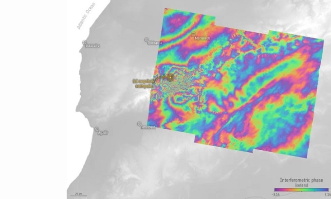
The image shows the extent of ground displacement caused by the Moroccan earthquake in September 2023. Photo: Copernicus
Satellite measurements reveal the extent of ground displacement caused by last week's 6.8 magnitude earthquake in Morocco, which killed nearly 3,000 people. The earthquake struck a rural area in the Atlas Mountains, about 75 km from Marrakech, on the evening of September 8th. According to the European Space Agency (ESA), this region lies on the boundary between the European and African tectonic plates, making it highly susceptible to earthquakes.
Radar measurements taken by Europe's Sentinel-1 satellites before and after the disaster revealed just how much the two tectonic plates shifted during the earthquake. According to the BBC, the ground was pushed up by up to 15 cm, while in other areas it subsided by 10 cm. The earthquake destroyed entire villages, burying families in rubble. Satellite imagery helped scientists and rescue teams assess the situation and the risk of subsequent tremors.
"Earth-orbiting satellites have unique capabilities, providing not only a wide field of view of the affected area but also detailed information," announced Simonetta Cheli, director of ESA's Earth Observation Program. "Because the Copernicus Sentinel-1 mission is equipped with radar, it can see through clouds and is often used to map severe flooding. In the case of the Moroccan earthquake, the mission's value lies in measuring the extent of ground displacement, information that is crucial after the crisis has passed and recovery efforts begin."
The two images used to create the interference pattern showing the extent of ground displacement were taken on August 30 (more than a week before the earthquake) and September 11 (three days after the disaster).
An Khang (According to Space )
Source link


Comment (0)