
According to a study by a Chinese scientific team published in the non-profit international scientific journal The Cryosphere on July 6, researchers from the Institute of Tibetan Plateau Research under the Chinese Academy of Sciences revealed that the average depth of the snow layer on Mount Everest is about 9.5 meters - much deeper than previously known.
This discovery could completely change the understanding of climate change at extreme altitudes.
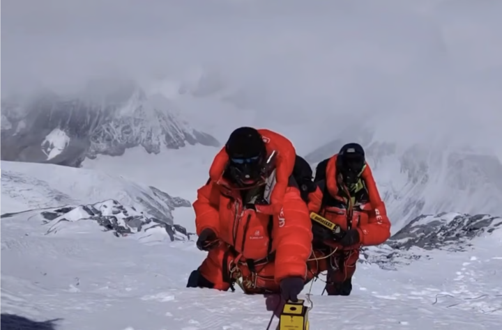
Scientists from the Tibetan Plateau Research Institute release results from data from their expedition last year. (Photo: The Cryosphere)
Previous estimates placed the depth in the range of 0.92–3.5 meters, but also acknowledged that these measurements were inconsistent and lacked great certainty.
“Our measurements show a surprising average snow depth at the summit of about 9.5 meters, much deeper than previous estimates,” said Professor Yang Wei from the Chinese Academy of Sciences.
The findings come from a test conducted by an expedition in April and May last year, which used ground-penetrating radar to record data along the north slope of Mount Everest at an altitude of over 7,000 metres.
According to the report, 26 measurement points concentrated at the summit showed that the snow had an average depth of about 9.5 meters, but it was noted that this result could vary within a range of plus or minus 1.2 meters.
These results also showed a distinct difference between the snow and rock surfaces, allowing the team to determine the boundary between the two materials.
“Such uniformity not only demonstrates the reliability of repeated radar measurements in this limited area, but also provides insight into the relatively flat terrain along the Everest ridge,” the report said.
Previous measurement efforts were limited by factors such as “snow density, pole length and altitude challenges,” said Professor Yang.
Comparing snow depths over different periods could be useful in understanding the effects of human-caused climate change at extreme altitudes in the Himalayas, the researchers say in the paper.
“The snow and glaciers on Mount Everest are drivers of climate change, and so provide a potential natural backdrop for understanding how climate change is occurring at extreme altitudes and how far-reaching its effects are,” the report said.
Chinese experts say it is necessary to drill snow cores and conduct more ground-penetrating radar measurements on Mount Everest to learn about the changing trends of snow at this altitude.
One of the key findings of this experiment was the discovery of disagreement about the exact height of Mount Everest. Due to changes in snow levels, gravity drift, light refraction, and other factors, the actual height of the mountain can vary from what is known.
Everest is the highest peak in the Himalayas, but the maximum height of the peak is inconsistent.
In 2020, Beijing and Kathmandu jointly announced the latest measurement of 8,850 meters, slightly higher than Nepal's previous measurement and about 4 meters higher than China's estimate at the time.
Phuong Thao (Source: SCMP)
Useful
Emotion
Creative
Unique
Wrath
Source


Comment (0)