
 |
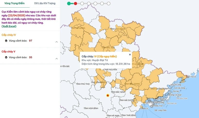
| Areas at risk of forest fires at dangerous levels. (Source: Department of Forestry and Forest Protection) |
After the “cooling” rain that occurred yesterday afternoon, today, April 22, widespread heat waves reappeared in the North, as well as provinces from Thanh Hoa to Phu Yen, the Central Highlands and the South; the risk of forest fires is very high.
According to the National Center for Hydro-Meteorological Forecasting (Department of Hydro-Meteorology, Ministry of Agriculture and Environment), today and tomorrow, April 23, the main weather in the Northern region (including the capital Hanoi) will be hot and dry, with high temperatures ranging from 35-36 degrees Celsius, with some places above 38 degrees Celsius.
In the Central region, the common temperature is 36-38 degrees Celsius, some places above 38 degrees Celsius. In the Central Highlands and the South, the common temperature is 35-36 degrees Celsius, some places above 36 degrees Celsius.
Notably, due to high temperatures, dry weather and the southwest wind tending to become stronger, especially in the Central region, the possibility of fire is very high.
In the above weather conditions, on the morning of April 22, the Department of Forestry and Forest Protection warned of a level V forest fire risk (extremely dangerous level) for 35 forest areas in the South; and a level IV forest fire risk (dangerous level) for 97 locations in the North and some provinces in the South and Central Highlands.
Specifically, forest areas at risk of forest fires at level V include: Bu Dop, Dong Phu, Phuoc Long (Binh Phuoc province); Tan Bien, Go Dau, Tay Ninh city, Tan Chau, Trang Bang, Ben Cau, Duong Minh Chau (Tay Ninh); Nhon Trach, Long Thanh, Trang Bom, Bien Hoa, Long Khanh city (Dong Nai); An Bien, An Minh, U Minh Thuong, Rach Gia, Kien Hai, Kien Luong, Hon Dat (Kien Giang province); Nga Nam town, Chau Thanh, Long Phu (Soc Trang); Tran Van Thoi, U Minh, Ngoc Hien, Nam Can, Thoi Binh (Ca Mau); Phu My, Chau Duc, Dat Do (Ba Ria-Vung Tau).
132 areas at risk of forest fires at level IV, concentrated in the following localities: Do Son, Thuy Nguyen, An Lao, An Duong (Hai Phong); Tam Dao, Phuc Yen city, Lap Thach, Binh Xuyen (Vinh Phuc); Bac Me, Ha Giang city, Vi Xuyen, Bac Quang, Quan Ba (Ha Giang); Thach An, Cao Bang city, Bao Lac, Trung Khanh, Quang Hoa, Hoa An, Ha Lang, Nguyen Binh (Cao Bang); Cho Moi, Bac Kan city, Ngan Son, Bach Thong, Cho Don, Ba Be (Bac Kan).
Along with that are Mong Cai, Ha Long, Dong Trieu, Cam Pha, Quang Yen (Quang Ninh province); Huu Lung, Binh Gia, Cao Loc, Dinh Lap, Van Quan, Lang Son city, Chi Lang, Van Lang (Lang Son); Chiem Hoa, Tuyen Quang city, Lam Binh, Ham Yen (Tuyen Quang); Thai Nguyen city, Dinh Hoa, Dai Tu (Thai Nguyen); Hiep Hoa, Yen The, Tan Yen, Luc Nam, Bac Giang city, Luc Ngan, Son Dong, Lang Giang, Yen Dung (Bac Giang).
Some areas at risk of forest fires at level IV in the South and Central Highlands include: Chu Krong Pa, Ayun Pa, Mang Yang, Chu Se, Duc Co, Chu Pah (Gia Lai province); Hon Quan, Bu Gia Map, Bu Dang, Dong Xoai, Phu Rieng (Binh Phuoc); Chau Thanh (Tay Ninh); Con Dao, Long Dien, Xuyen Moc (Ba Ria - Vung Tau); Tan Hung, Tan An, Moc Hoa, Duc Hoa, Ben Luc (Long An); Chau Thanh, Cao Lanh (Dong Thap); Tinh Bien, Cho Moi, Chau Thanh, Tri Ton, Chau Phu, Chau Doc (An Giang).
Other localities also at risk of level IV forest fires are Duyen Hai, Chau Thanh, Cau Ngang (Tra Vinh province); Dam Doi (Ca Mau province); Go Cong Dong, Tan Phuoc, Go Cong (Tien Giang province); Phu Quoc, Ha Tien, Chau Thanh, Giang Thanh (Kien Giang province); Ba Tri, Binh Dai (Ben Tre).
According to vietnamplus.vn
Source: https://baodanang.vn/xa-hoi/202504/canh-bao-nang-nong-dien-rong-hon-130-khu-vuc-co-nguy-co-chay-rung-rat-cao-4005632/
![[Photo] Prime Minister Pham Minh Chinh chairs a special Government meeting on the arrangement of administrative units at all levels.](https://vphoto.vietnam.vn/thumb/1200x675/vietnam/resource/IMAGE/2025/5/9/6a22e6a997424870abfb39817bb9bb6c)
![[Photo] Russian military power on display at parade celebrating 80 years of victory over fascism](https://vphoto.vietnam.vn/thumb/1200x675/vietnam/resource/IMAGE/2025/5/9/ce054c3a71b74b1da3be310973aebcfd)
![[Photo] Magical moment of double five-colored clouds on Ba Den mountain on the day of the Buddha's relic procession](https://vphoto.vietnam.vn/thumb/1200x675/vietnam/resource/IMAGE/2025/5/9/7a710556965c413397f9e38ac9708d2f)
![[Photo] General Secretary To Lam and international leaders attend the parade celebrating the 80th anniversary of the victory over fascism in Russia](https://vphoto.vietnam.vn/thumb/1200x675/vietnam/resource/IMAGE/2025/5/9/4ec77ed7629a45c79d6e8aa952f20dd3)


Comment (0)