 |
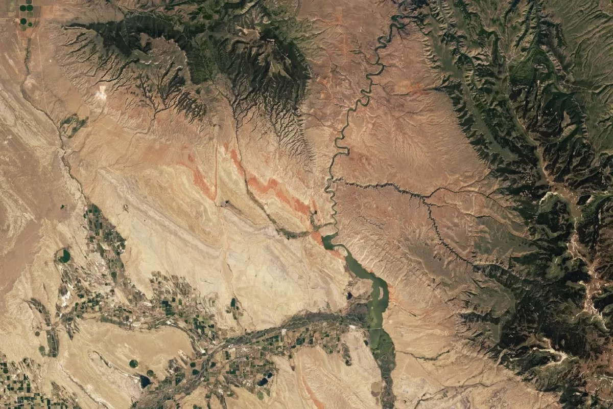
| NASA's Earth Observatory shows rusty rock folds next to Bighorn Canyon between Wyoming and Montana. (Source: NASA) |
These images, taken by the Landsat 9 satellite in June 2024, show red rock bands carved deep into the ground in the states of Montana and Wyoming – evidence that scientists say is the result of a “super monsoon” that occurred about 220 million years ago.
The discovery was centered in the Chugwater geologic region of the Bighorn Basin – an oval-shaped depression surrounded by six major mountain ranges that stretches about 150 miles through Montana and Wyoming. Known for its rich fossil deposits, the area is a treasure trove of research into Earth’s history.
Scientists explain that the distinctive red color of the rock layers is the result of widespread sediment oxidation – a consequence of violent climate fluctuations at the end of the Triassic, when North America was still part of the supercontinent Pangaea. Satellite images also clearly show large geological folds cutting across the terrain – evidence of millions of years of tectonic movements, as continental plates gradually separated from Pangaea and restructured into the continents we know today.
During that period, intense “super monsoons” swept across Pangaea’s tropical belt, creating extreme wet-dry cycles, the researchers say. These dramatic climate changes accelerated the “rusting” of sediments, leaving their distinctive marks on the landscape today.
Today, the Bighorn Canyon area is part of the National Recreation Area, established in 1966 after the completion of the Yellowtail Dam. It encompasses more than 70 miles of water along the Bighorn River, attracts over 200,000 visitors each year, and is a unique destination for those who want to explore the geological history and indigenous culture of this land.
Source: https://baoquocte.vn/bat-mi-dau-tich-ve-sieu-gio-mua-co-dai-moi-duoc-nasa-cong-bo-311716.html


![[Photo] Buddha's Birthday 2025: Honoring the message of love, wisdom, and tolerance](https://vphoto.vietnam.vn/thumb/1200x675/vietnam/resource/IMAGE/2025/5/12/8cd2a70beb264374b41fc5d36add6c3d)


![[Photo] Prime Minister Pham Minh Chinh starts construction of vital highway through Thai Binh and Nam Dinh](https://vphoto.vietnam.vn/thumb/1200x675/vietnam/resource/IMAGE/2025/5/12/52d98584ccea4c8dbf7c7f7484433af5)


Comment (0)