
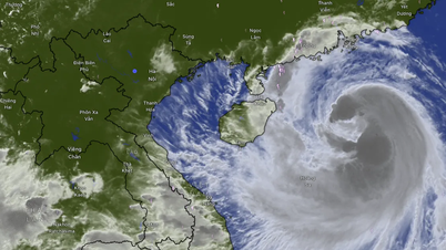
Last night, a tropical depression in the eastern Philippines intensified into Typhoon Trami. The storm is forecast to move into the East Sea.
The Japan Meteorological Agency reported that last night (October 21), the tropical depression in the eastern Philippines strengthened into storm Tra Mi (storm Trami).


The National Center for Hydro-Meteorological Forecasting forecasts that the storm will move mainly in a West-Northwest direction. By 4 p.m. on October 22, the storm's eye will be in the sea east of the Philippines. The strongest wind near the storm's eye is level 8 (62-75 km/h), gusting to level 11. Waves will be 3-4 meters high.
The meteorological agency said that around October 25, the storm is likely to move into the East Sea.
From around the afternoon and night of October 24, the eastern sea area of the North East Sea (east of 118.5 degrees East longitude) will have winds gradually increasing to level 8, near the storm center at level 9-10, gusting to level 12; very rough seas, waves 3-5m high, thunderstorms with dangerous whirlwinds.
Since January 1, 2000, typhoons in the Northwest Pacific have been named according to a new list of names. The new names are proposed by 14 countries and territories in the Asia-Pacific region that are members of the Typhoon Committee of the World Meteorological Organization (WMO). Each member provides 10 names, making a list of 140 typhoon names.
Storms forming in the Northwest Pacific are named by the WMO and assigned to the Tokyo Tropical Storm Warning Center of the Japan Meteorological Agency.
The Tokyo Tropical Storm Center - Japan Meteorological Agency will use the names in the bank of 140 names above to name storms in the region.
The storm names that Vietnam contributed are Son Tinh, Co May, Bang Lang, Ba Vi, Con Son, Son Ca, Tra Mi, Ha Long, Song Da, Sao La. The names Lekima, Hoa Mai, and Vam Co were also nominated by Vietnam.

Source: https://vietnamnet.vn/bao-tra-mi-hinh-thanh-o-phia-dong-philippines-du-bao-vao-bien-dong-2334205.html
![[Photo] Closing ceremony of the 18th Congress of Hanoi Party Committee](https://vphoto.vietnam.vn/thumb/1200x675/vietnam/resource/IMAGE/2025/10/17/1760704850107_ndo_br_1-jpg.webp)


![[Photo] Nhan Dan Newspaper launches “Fatherland in the Heart: The Concert Film”](https://vphoto.vietnam.vn/thumb/1200x675/vietnam/resource/IMAGE/2025/10/16/1760622132545_thiet-ke-chua-co-ten-36-png.webp)


Comment (0)