
SGGPO
Due to the impact of the storm, on the evening of October 19, the Gulf of Tonkin (including the island districts of Co To and Bach Long Vi) had strong winds of level 6-7. The area near the center of the storm had strong winds of level 8-9, gusting to level 11, very rough seas, waves 2-4m high. All boats, anchorages, aquaculture areas, and sea dykes in this area were affected by strong winds and big waves.
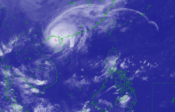 |
| The area near the storm center is at level 8-9, gusting to level 11, with very rough seas and waves 2-4m high. Photo: National Center for Hydro-Meteorological Forecasting |
According to the National Center for Hydro-Meteorological Forecasting, at 9:00 p.m. on October 19, the center of storm No. 5 was at approximately 20.7 degrees North latitude; 109.0 degrees East longitude. The strongest wind speed is level 8-9 (62-88 km/h), gusting to level 10. It is forecasted that in the next 3 hours, storm No. 5 will move mainly northward at a speed of about 10 km/h. Due to the influence of storm No. 5, Bach Long Vi island has strong winds of level 6, gusting to level 7.
It is forecasted that by 7 p.m. on October 20, the center of the storm will be at approximately 20.3 degrees North latitude; 108.2 degrees East longitude, in the northern area of the Gulf of Tonkin. The strongest wind near the center of the storm is level 7, gusting to level 9.
The storm moves north, then southwest at a speed of 5-10 km/h and gradually weakens into a tropical depression. The dangerous area affected by the storm is north of latitude 19 degrees north, west of longitude 110 degrees east. The Gulf of Tonkin has a level 3 natural disaster risk.
At 7:00 p.m. on October 21, the center of the tropical depression was at about 18.6 degrees North latitude; 107.4 degrees East longitude, in the southern part of the Gulf of Tonkin. The strongest wind near the center of the tropical depression was below level 6. The tropical depression moved in a south-southwest direction at a speed of about 10 km/h and weakened into a low pressure area. The dangerous area affected by the tropical depression was north of latitude 19 degrees North, west of longitude 110 degrees East.
Due to the impact of the storm, on the evening of October 19, the Gulf of Tonkin (including the island districts of Co To and Bach Long Vi) had strong winds of level 6-7. The area near the center of the storm had strong winds of level 8-9, gusting to level 11, very rough seas, waves 2-4m high. All boats, anchorages, aquaculture areas, and sea dykes in this area were affected by strong winds and big waves.
From early morning on October 20, coastal areas in the North will have strong gusts of wind at level 6-7. Some places along the coast of Quang Ninh - Hai Phong will have strong winds at level 6, gusts at level 7-8. From the night of October 19 to the morning of October 21, coastal areas in the Northern Delta and the Northeast of the North will likely experience moderate rain, with some places experiencing heavy rain.
Source

![[Photo] Prime Minister Pham Minh Chinh chairs Government Standing Committee meeting on Gia Binh airport project](https://vphoto.vietnam.vn/thumb/1200x675/vietnam/resource/IMAGE/2025/5/10/6d3bef55258d417b9bca53fbefd4aeee)


Comment (0)