
Forecasts indicate that Typhoon No. 3 will continue to intensify, with strong winds potentially reaching level 15, and gusts exceeding level 17 in areas near the storm's center. Over the next 24 hours, sea waves in the eastern part of the northern South China Sea will reach 5-7 meters in height, and 7-9 meters near the storm's center.
|
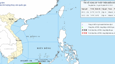
Location and trajectory of Typhoon No. 3. (Source: nchmf.gov.vn) |

According to the National Center for Hydro-Meteorological Forecasting, at 10:00 AM on September 4th, the center of Typhoon No. 3 was located at approximately 19.0 degrees North latitude and 117.5 degrees East longitude, in the eastern part of the North East Sea, about 730km east of Hainan Island (China). The strongest winds near the center of the typhoon reached level 12 (118-133 km/h), with gusts up to level 15. The typhoon was moving in a West-Northwest direction at a speed of about 10 km/h.
As of 10:00 AM on September 5th, the typhoon's center was located at approximately 19.3 degrees North latitude and 115.2 degrees East longitude, about 470km east of Hainan Island (China). The strongest winds near the center of the typhoon reached levels 13-14, with gusts up to level 17. The typhoon was moving in a West-Northwest direction at a speed of about 10-15km/hour.
As of 10:00 AM on September 6th, the typhoon's center was located at approximately 19.7 degrees North latitude and 111.9 degrees East longitude, about 120km east of Hainan Island (China). The strongest winds near the center of the typhoon reached levels 14-15, with gusts exceeding level 17. The typhoon was moving in a West-Northwest direction at a speed of approximately 10-15 km/hour.
As of 10:00 AM on September 7th, the typhoon's center was located at approximately 20.5 degrees North latitude and 107.9 degrees East longitude, over the Gulf of Tonkin. The strongest winds near the center of the typhoon reached levels 12-13, with gusts up to level 16. The typhoon was moving in a West-Northwest direction at a speed of about 15-20 km/hour, entering the Gulf of Tonkin.
Over the next 72 to 120 hours, the storm will move mainly in a west-northwest direction, traveling at 15-20 km per hour, and its intensity will continue to gradually decrease.
Due to the influence of typhoon No. 3, the northern area of the East Sea is experiencing strong winds of force 9-11, with winds near the center of the typhoon reaching force 12-14, gusting to force 17; the sea is extremely rough.
Forecasts indicate that from September 5-6, Typhoon No. 3 will continue to intensify, with strong winds potentially reaching level 15, and gusts exceeding level 17 in areas near the storm's center.
Over the next 24 hours, in the eastern part of the northern South China Sea, sea waves will reach 5-7 meters, and 7-9 meters near the storm's center. From September 5-6, waves may gradually increase to 9-11 meters. The sea will be extremely rough. Vessels operating in these dangerous areas are likely to be affected by strong winds and high waves.
According to Nhan Dan Newspaper
Source: https://baophutho.vn/bao-so-3-du-bao-manh-cap-12-13-giat-cap-16-khi-vao-vinh-bac-bo-218276.htm


Comment (0)