
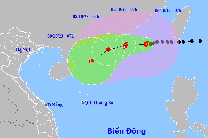
On the afternoon of October 6, the National Center for Hydro-Meteorological Forecasting said that storm Koinu ( storm number 4 ) has strengthened by one level in the past hours, after moving into the sea southeast of Guangdong province (China).
Specifically, at 4 p.m., the center of the storm was about 290 km east-southeast of Hong Kong (China). The strongest wind near the center of the storm was level 12-13 (118-149 km/h), gusting to level 16, moving west at about 10 km/h.
With this intensity, storm Koinu is at its strongest stage during its movement across the East Sea.

Forecast of the path of storm Koinu in the East Sea on the afternoon of October 6. (Photo: VNDMS).
Over the next 24 hours, the storm will continue to maintain its direction and speed, gradually decreasing in intensity. At 4 p.m. on October 7, the center of the storm was approximately 100 km southeast of Hong Kong (China). The strongest winds near the center of the storm reached level 11-12, gusting to level 15.
Over the next 48 to 72 hours, the storm will move along the coast of mainland China and turn southwest. When it enters the northeastern sea of Hainan Island (China) around the afternoon of October 9, the storm will weaken into a tropical depression with the strongest winds of level 7, gusting to level 9.
From 72 to 96 hours later, the tropical depression moved mainly in the southwest direction, traveling about 10km per hour and gradually weakened.
The meteorological agency warns that in the next 24 to 48 hours, the northern sea area of the North East Sea will have strong winds of level 7-10, the area near the storm's center will have strong winds of level 11-13, gusting to level 16. Waves will be 4-6m high, in some places 6-8m, and the sea will be very rough. All ships operating in this area will be affected by strong storm winds.
The Standing Office of the National Steering Committee for Natural Disaster Prevention and Control requested functional units of coastal provinces and cities from Quang Ninh to Khanh Hoa to closely monitor the storm's developments.
Meteorological experts say that due to interaction with cold air from the North, the forecast for storm No. 4 is still complicated and unpredictable, and it is necessary to update the latest forecasts.
On land, from this evening (October 6) to tomorrow morning, the Northern region will experience showers and thunderstorms, with moderate rain in mountainous and midland areas, with heavy to very heavy rain in some places with rainfall of 20-50mm, and over 100mm in some places.
Tomorrow afternoon and night, rain will spread to the area from Thanh Hoa to Quang Binh . Thunderstorms may cause tornadoes, lightning, hail and strong gusts of wind. Localized heavy rain may cause flooding in low-lying areas and the risk of flash floods and landslides in mountainous areas.
Previously, the National Center for Hydro-Meteorological Forecasting stated that the storm would not affect the mainland of our country. However, the cold air mass will cause thunderstorms, tornadoes, lightning, and strong gusts of wind in many places in the Northern and North Central regions.

Cold air is coming, heavy rain in many places in the North
The cold air mass has caused showers and thunderstorms in the North, with some areas experiencing heavy rain in the mountains and midlands; ending the recent long period of sunshine.
Storm Koinu is swirling in the East Sea, thunderstorms in the North from this evening
Storm Koinu (storm number 4) is showing signs of weakening rapidly after entering the East Sea. The storm is forecast to weaken and dissipate at sea. The North is about to experience cold air with heavy rain in many places.
Source

![[Photo] Readers line up to visit the photo exhibition and receive a special publication commemorating the 135th birthday of President Ho Chi Minh at Nhan Dan Newspaper](https://vphoto.vietnam.vn/thumb/1200x675/vietnam/resource/IMAGE/2025/5/17/85b3197fc6bd43e6a9ee4db15101005b)

![[Photo] Nearly 3,000 students moved by stories about soldiers](https://vphoto.vietnam.vn/thumb/1200x675/vietnam/resource/IMAGE/2025/5/17/21da57c8241e42438b423eaa37215e0e)


Comment (0)