
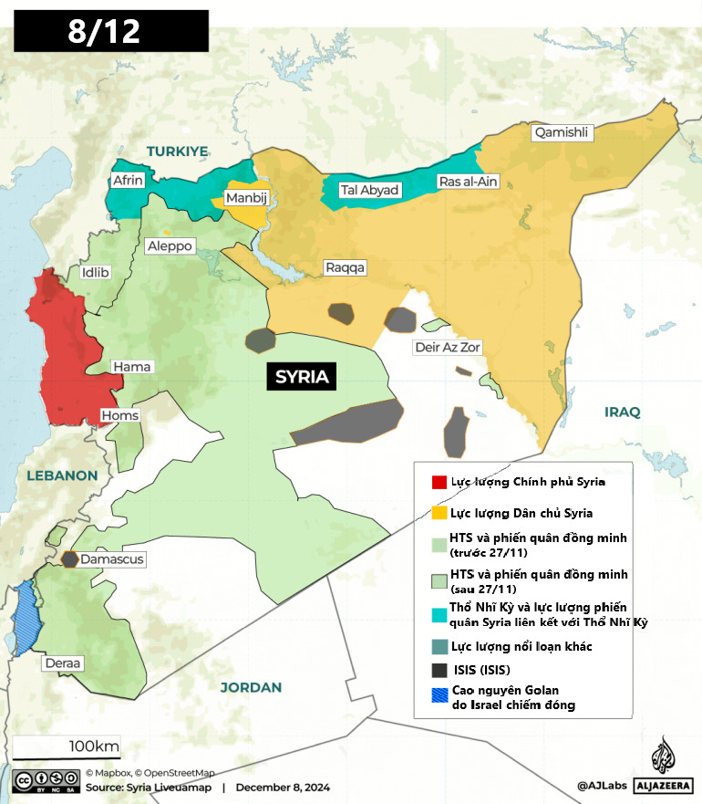
(CLO) Early on the morning of December 8, Syrian opposition fighters announced that they had captured the capital Damascus and that President Bashar al-Assad had fled the country.
In just 11 days, President Bashar al-Assad's 24-year rule ended. The maps below provide a day-by-day overview of the state of control over the territory.
Before November 27
Before November 27, Syrian opposition forces were largely confined to their stronghold in the northwestern province of Idlib, following a ceasefire brokered by Turkish President Recep Tayyip Erdogan and Russian President Vladimir Putin in March 2020.
The map below shows Syria's territorial control before November 27.
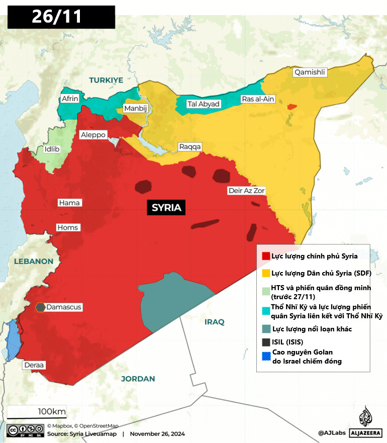
In fact, there are four main groups competing for control of territory in Syria, including:
1. Syrian Government Forces: The Syrian army along with the National Defense Forces, a paramilitary group supporting the government.
2. Syrian Democratic Forces (SDF): The Kurdish-led group, supported by the US, controls several areas in eastern Syria.
3. HTS and allied rebel groups: The jihadist group Hayat Tahrir al Sham (HTS) is a new version of the al-Nusra Front, which pledged allegiance to al-Qaeda before breaking ties in 2016.
4. Türkiye and Türkiye-aligned rebel forces: Turkish-backed forces, such as the Syrian National Army, fight in northern Syria.
Day 1: November 27
On November 27, just one day after the ceasefire between Israel and Lebanon came into effect, Syrian opposition forces, led by HTS, launched an attack from their base in Idlib province, northwestern Syria.
The rebel group said the attacks were in retaliation for recent Syrian government attacks on cities in Idlib, including Ariha and Sarmada.
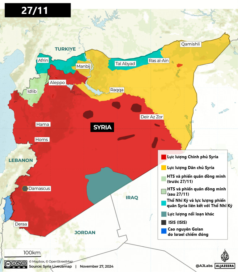
By evening, the group had captured at least 19 towns and villages from pro-regime forces, including military sites, as they advanced into western Aleppo province. The Syrian government responded by shelling rebel-held areas while the Russian air force carried out airstrikes.
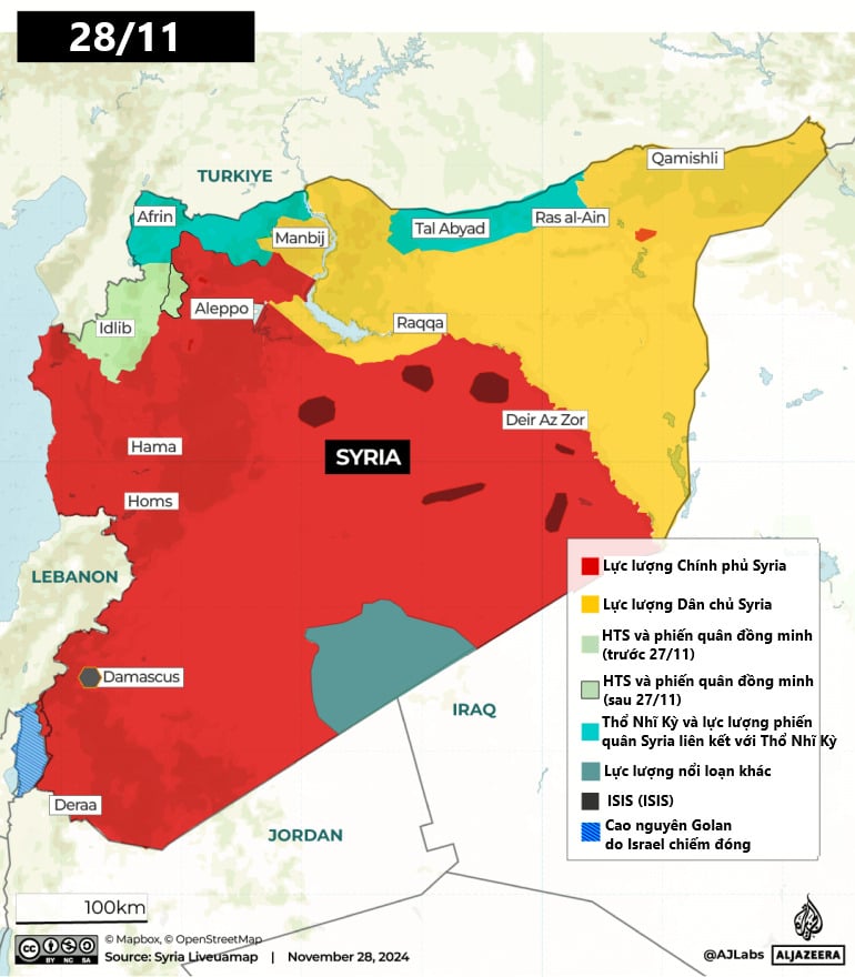
Day 2: November 28
By November 28, rebels had captured more territory and driven government forces from villages in eastern Idlib, then began advancing toward the M5 highway, a strategic route leading south to the capital Damascus, some 300 kilometers away.
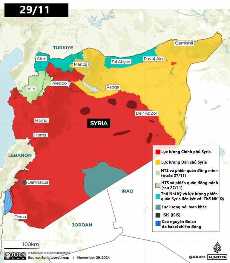
Day 3: November 29
Rebels entered parts of Aleppo on November 29 after detonating two car bombs and clashing with government forces on the western edge of the city, according to a Syrian war monitor and militants. Syrian state TV said Russia was providing air support to the Syrian army.
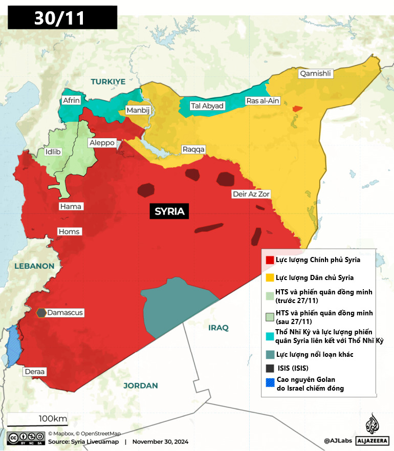
Day 4: November 30
By November 30, online images and videos showed rebel fighters posing for photos next to the Aleppo Citadel as they entered the city. After capturing Aleppo, the rebels advanced south toward Hama.
Day 5: December 1
By December 1, Syrian and Russian warplanes had intensified airstrikes on the city of Idlib and positions in Aleppo as government forces tried to slow the advance of opposition fighters.
In his first public comments since the offensive began, President al-Assad said his forces would continue to defend “the stability and territorial integrity of the government against terrorists and their supporters”.

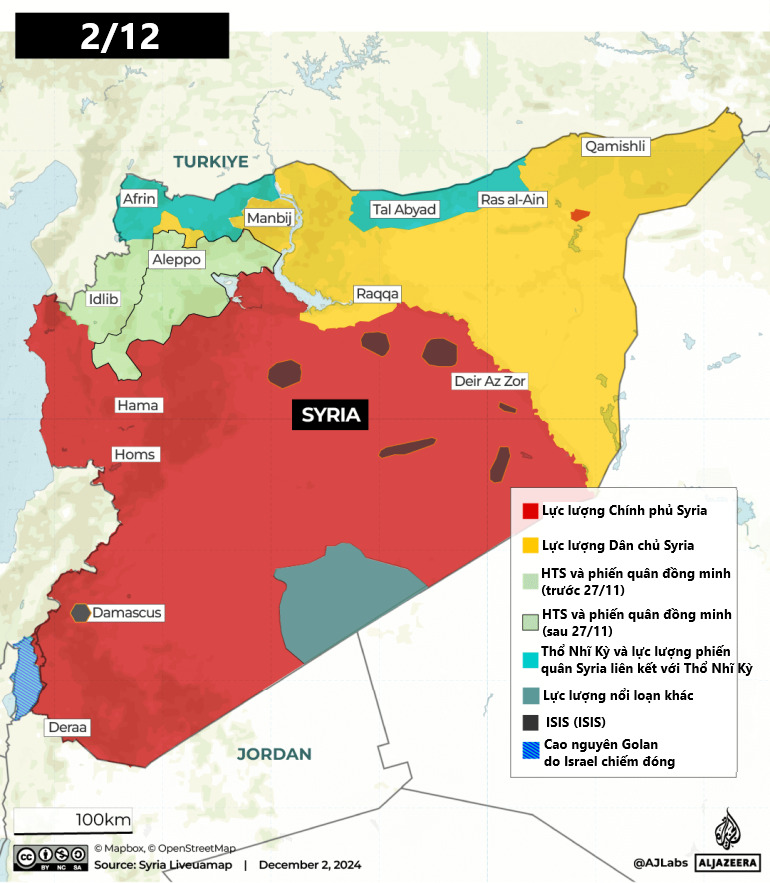
Day 6: December 2
Fierce battles continue on the outskirts of Hama as Syrian opposition forces advance on the strategic city – Syria's fourth largest.
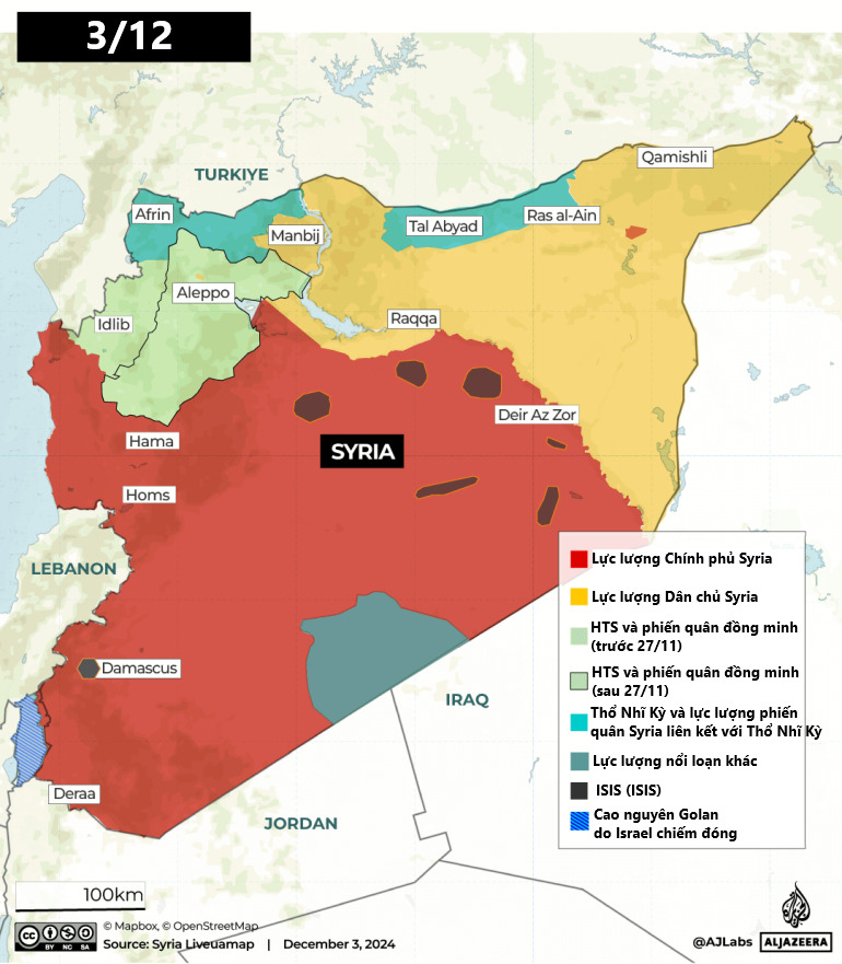
Day 7: December 3
The Syrian government said its counterattack had pushed back opposition fighters trying to advance into Hama. In contrast, opposition forces said they had captured more Syrian troops and Iranian-backed fighters in the fierce fighting.
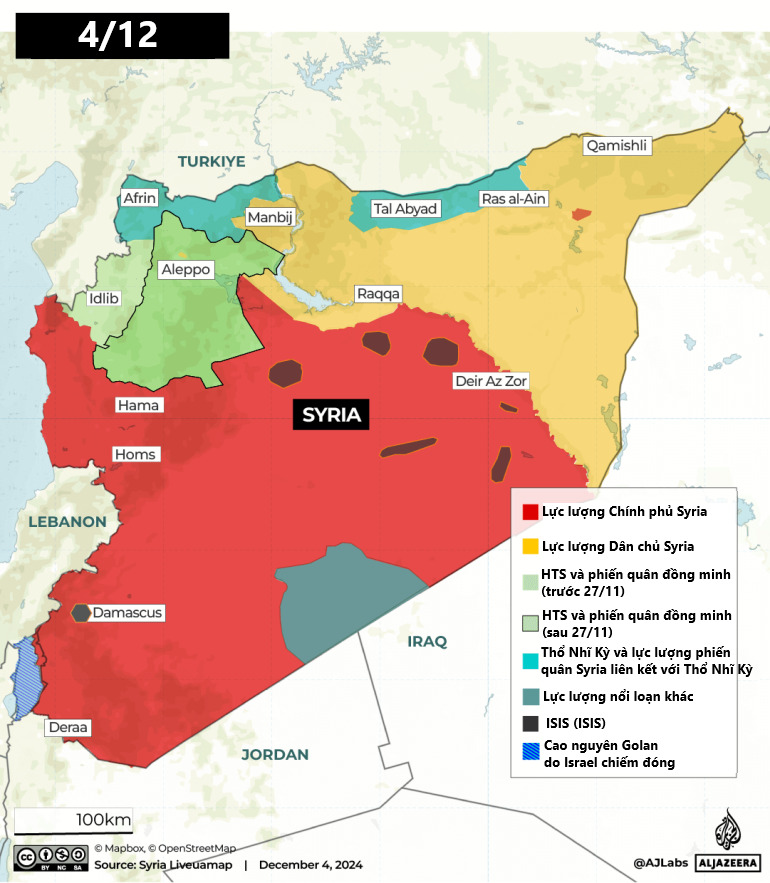
Day 8: December 4
Opposition fighters continue to advance further south as they capture more towns in Hama province.
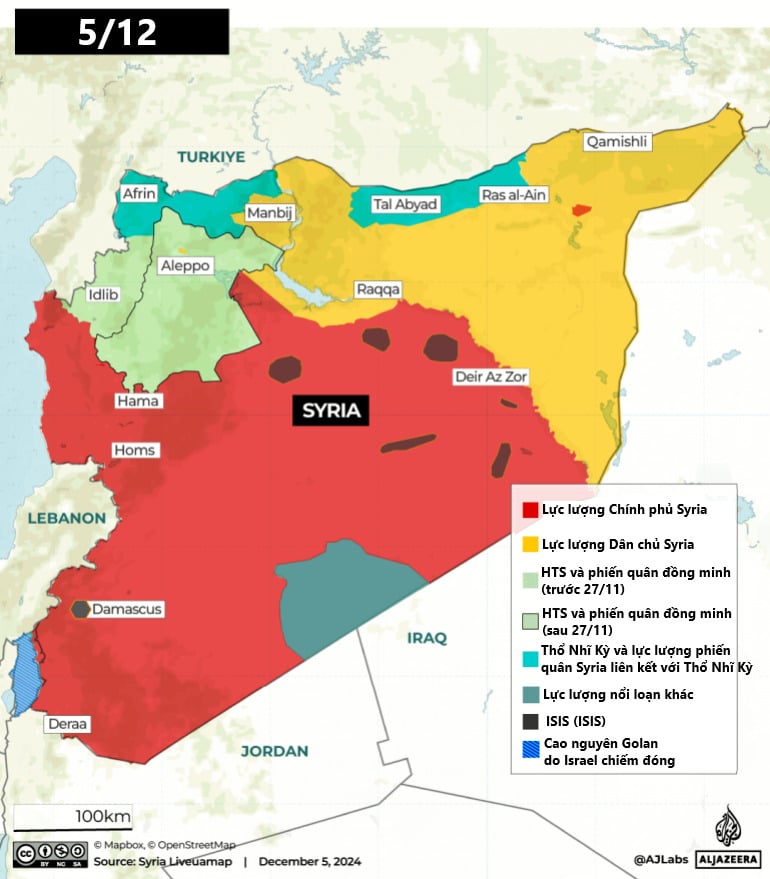
Day 9: December 5
By December 5, the rebels claimed full control of Hama. The capture of the city brought them one step closer to cutting off the coastal cities of Tartus and Latakia from the rest of the country. Latakia is an important political stronghold for Mr. al-Assad and a strategic naval base for Russia.
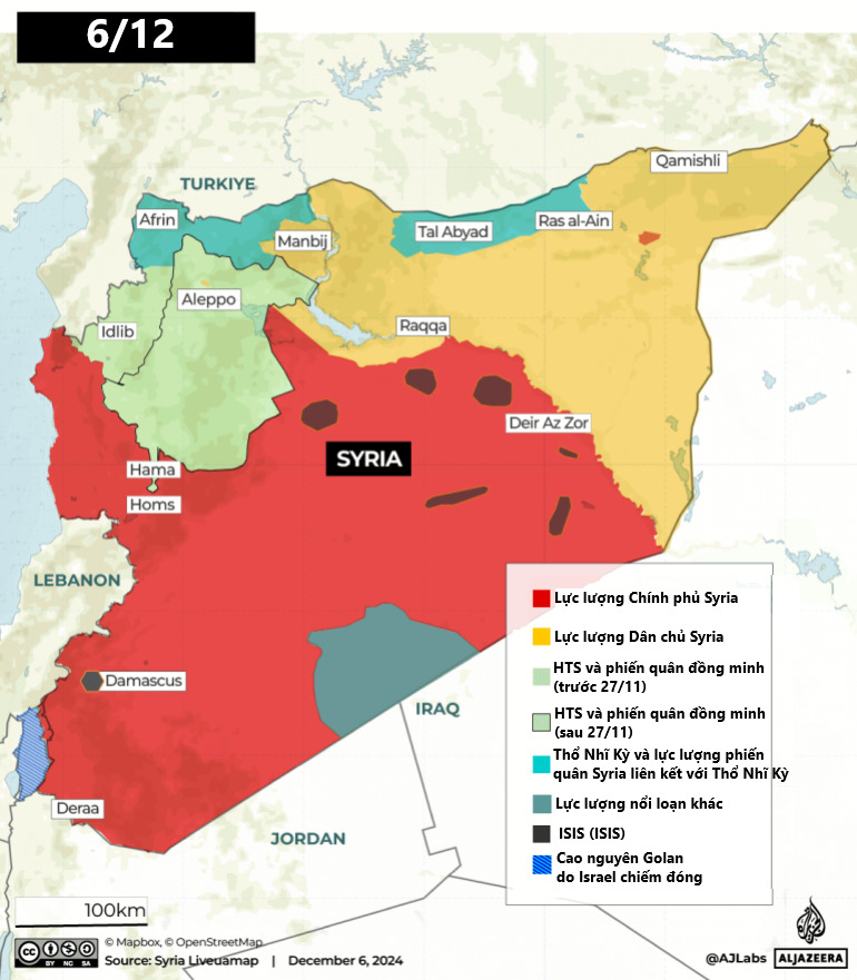
Day 10: December 6
The capture of Hama opens the way to Homs, Syria’s third largest city. Homs, a key crossroads connecting Damascus to Syria’s coastal areas, lies about 46km south of Hama. Syrian government forces have carried out several airstrikes on the main road in an attempt to halt the opposition advance.
Day 11: December 7
On December 7, southern forces began to move in, and opposition fighters based in Deraa said they had taken control of the city, the fourth strategic loss for President Bashar al-Assad's forces in a week. Deraa, just a few kilometers from the border with neighboring Jordan, is known as the cradle of the 2011 revolution.
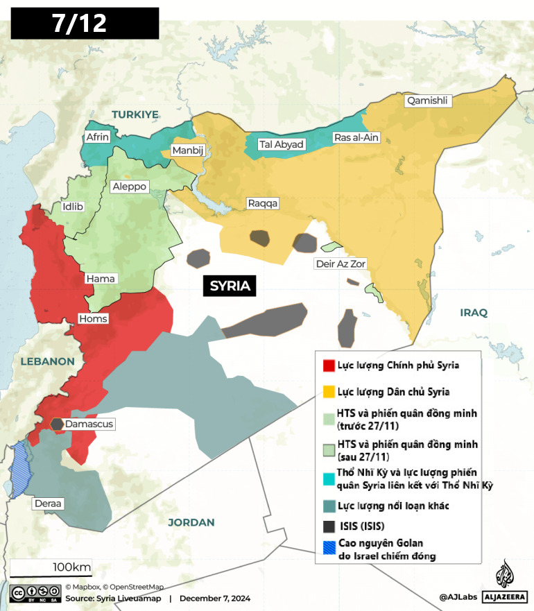
On the same day, rebel fighters advanced to within a few kilometers of the capital Damascus. By evening, they had reached the outskirts, and by early morning on December 8, the fighters had captured the capital.
Ngoc Anh (according to AJ)
Source: https://www.congluan.vn/ban-do-11-ngay-quan-noi-day-lat-do-chinh-quyen-syria-post324753.html
![[Photo] Ready for the top competitions of Vietnamese table tennis](https://vphoto.vietnam.vn/thumb/1200x675/vietnam/resource/IMAGE/2025/5/18/9c547c497c5a4ade8f98c8e7d44f5a41)
![[Photo] Party and State leaders attend the special art program "You are Ho Chi Minh"](https://vphoto.vietnam.vn/thumb/1200x675/vietnam/resource/IMAGE/2025/5/18/6895913f94fd4c51aa4564ab14c3f250)


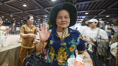
![[Photo] Many young people patiently lined up under the hot sun to receive a special supplement from Nhan Dan Newspaper.](https://vphoto.vietnam.vn/thumb/1200x675/vietnam/resource/IMAGE/2025/5/18/6f19d322f9364f0ebb6fbfe9377842d3)


Comment (0)