
A tropical depression formed in the southern sea of the South China Sea, combined with cold air, caused heavy rain in the Central and South Central regions and the Central Highlands from December 23-26.
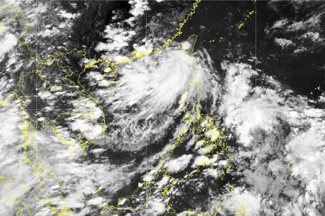
According to the National Center for Hydro-Meteorological Forecasting, this morning (December 21), a low pressure area in the southern sea of the South China Sea has strengthened into a tropical depression. At 10am, the strongest wind near the center of the tropical depression was level 6 (39-49km/h), gusting to level 8; barely moving.
Due to the influence of the tropical depression, at Huyen Tran station there were strong winds of level 7, gusting to level 8; Phu Quy island station had gusting to level 7; Truong Sa island station had strong winds of level 6, gusting to level 7. The North East Sea area had strong northeast winds of level 6-7.
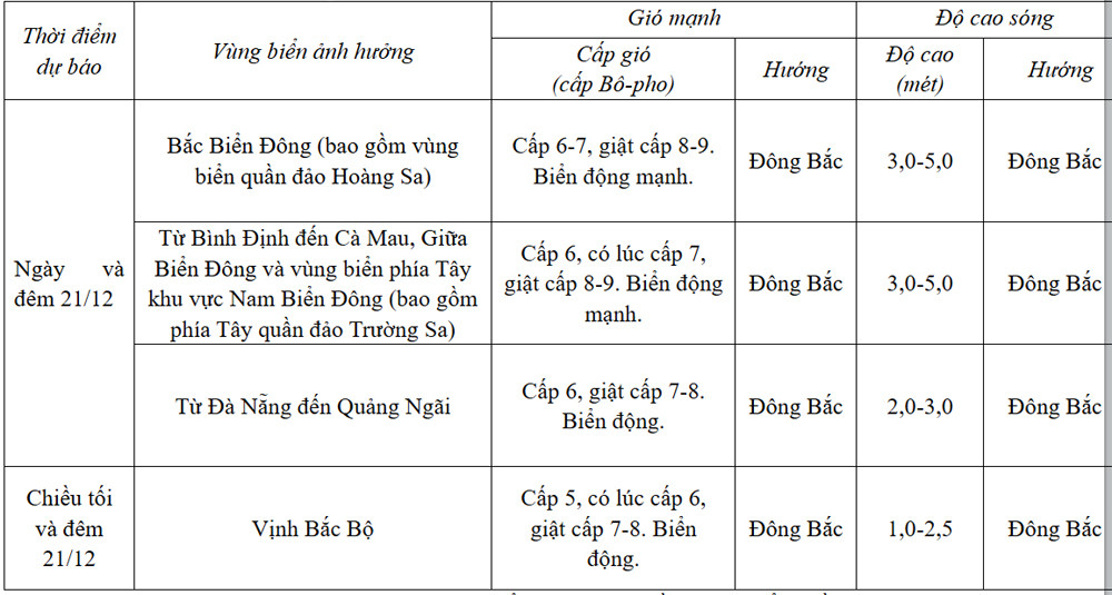
Forecast for the next 24 hours :
In addition, today and tonight, the South China Sea (including the waters of the Truong Sa archipelago) will have showers and thunderstorms. During thunderstorms, there is a possibility of tornadoes and strong gusts of wind of level 7-8.
Tomorrow day and night (December 22), in the North East Sea area (including the waters of Hoang Sa archipelago), the Northeast wind will be level 7, gusting to level 8-9. The sea will be rough; waves will be 4-6m high.
The sea area from Quang Ngai to Ca Mau, the central East Sea area, the western sea area of the southern East Sea area (including the western sea area of Truong Sa archipelago) has strong northeast wind at level 6, sometimes level 7, gusting to level 8-9. The sea is rough; waves are 3-5.5m high.
From Quang Tri to Quang Nam, strong northeast wind level 6, gust level 8. Rough sea; waves 2-4m high.
In the Gulf of Tonkin, strong northeast wind level 5, sometimes level 6, gusting to level 7-8. Rough sea; waves 1-3m high.
All vessels operating in the above areas are at high risk of being affected by cyclones, strong winds and large waves.
Heavy rain in Central region
The Southern Hydrometeorological Station said that in the next 1-2 days, the cold air will increase and shift to the east. The subtropical high pressure area will have an axis through the Central region. The Northeast wind over the sea area east of the South will operate with strong intensity.
From the next 3-10 days, cold air will continue to strengthen to the south, and will strengthen again around December 26-27. Above, subtropical high pressure will have stable intensity after encroaching on the west...
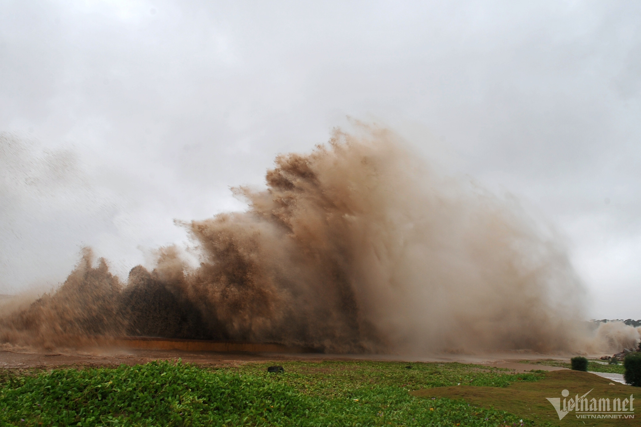
According to the National Center for Hydro-Meteorological Forecasting, due to the influence of the above weather patterns, from the night of December 23 to 26, in the Central and South Central regions, there will be moderate rain, heavy rain, locally very heavy rain and thunderstorms with common rainfall of 100-300mm, locally over 500mm.
From December 24-25, in the Eastern Central Highlands, there will be moderate rain, heavy rain, locally very heavy rain and thunderstorms with common rainfall of 60-120mm, locally over 200mm.
Regarding the weather forecast for the North in the coming days, the meteorological agency said that from December 21 to 23, the North will generally have no rain, sunny days. It will be cold, with some mountainous areas experiencing severe cold; from December 24 to 27, there will be rain in some places; from December 26 to 27, there will be scattered rain and light rain. It will be cold, with some mountainous areas experiencing severe cold.
North Central region , from December 21-27, scattered rain; cold weather.
In the Central and South Central regions, from December 21-22, there will be scattered showers and thunderstorms; the North will be cold. From December 23-26, there will be moderate rain, heavy rain, locally very heavy rain and thunderstorms. On December 27, there will be showers, locally heavy rain and thunderstorms. The North will be cold. During thunderstorms, there is a possibility of tornadoes, whirlwinds and strong gusts of wind.
Notably, from December 23-27, there is a possibility of a flood on rivers from Thua Thien Hue to Ninh Thuan. There is a high risk of flash floods, landslides in mountainous areas, flooding in low-lying areas along rivers and urban areas in the provinces from Thua Thien Hue to Ninh Thuan.
In the Central Highlands, from December 21-23, there will be scattered showers and thunderstorms in some places. From December 24-27, there will be scattered showers and thunderstorms in some places, with some places experiencing heavy rain; in the East, from December 24-25, there will be moderate to heavy rain, with some places experiencing very heavy rain and thunderstorms.
In the South, from December 21-23, there will be scattered showers and thunderstorms in some places. From December 24-27, there will be scattered showers and thunderstorms in some places. In the East, from December 24-25, there will be rain, moderate rain, locally heavy rain and thunderstorms.
As for Hanoi weather , from December 21-23, it is generally rainless, sunny during the day. Cold weather. From December 24-27, there will be rain in some places; on December 26-27, there will be rain, scattered light rain. Cold weather.

Weather forecast for the next 10 days: Cold air increases, the North is still cold at 10 degrees
Unseasonal tropical depression is about to form in the East Sea, heavy rain in the Central region
Source: https://vietnamnet.vn/ap-thap-nhiet-doi-hinh-thanh-o-nam-bien-dong-mien-trung-co-dot-mua-lon-2354937.html


![[Photo] Prime Minister Pham Minh Chinh chairs Government Standing Committee meeting on Gia Binh airport project](https://vphoto.vietnam.vn/thumb/1200x675/vietnam/resource/IMAGE/2025/5/10/6d3bef55258d417b9bca53fbefd4aeee)


Comment (0)